
THE SIGN WE ALL LOVE TO SEE!!!!!
ARKANSAS: Mountain View to Melbourne, Arkansas Run
Start the route in the town of Mountain View, AR which sits about 85 miles due north of Little Rock. From there you take State Road 14 north out of Mountain View, AR for about 6 miles and then look for State Road 9 (you will see signs pointing the way to Melbourne, AR). Take a right on State Road 9 and you'll be heading east and cross the White river and you are on your way to Melbourne, AR. For the next 20 or so miles, stay on State Road 9 and take it in to Melbourne (note: State Road 9 is part of the Ozark National forest).
ARKANAS: Sylamore Scenic Byway
Start your route in Calico Rock located in north central Arkansas. Take Hwy 5 south and just past Allison you turn west on Hwy 14 towards the town the routes end point of Marshall, AR. Here I found the town full of canoes. Located need the Buffalo River the town has lots to offer natural lovers.
ARKANSAS: Push Mountain Road - Arkansas
Start your run from the town of "Mountain View" Arkansas, located in north central of Arkansas. From Mountain View take highway 14 North. About 10 miles past Blanchard Springs Caverns take the road to the right with the small sign "Push Mountain Road" - AKA Arkansas Route 341. Note: "the highway department has quit putting up the small "Push Mountain Road" sign at Hwy 14 as it kept getting stolen. The sign that marks the intersection is the "Arkansas 341" sign. There is a mileage sign at the intersection that points toward 341 and says "Mountain Home 35 miles".
Note aternative directions for "Push Mountain Loop": The directions are as follows: Take Hwy 62 East out of Harrison through Yellville, AR toward Mountain Home. At Mountain Home take SR-201 South to SR-341. SR-341 South will dead end into Hwy 14. Take 14 West (right) to Harriet, AR and Ben Hur. Turn left onto Hwy 27. Follow Hwy 27 south/west to Hwy 16 West to Witts Spring and Ben Hur. Hwy 16 will then hit Hwy 7. Take Hwy 7 north back to Harrison. In the Dogpatch area, you will pass by The HUB at Hwy 7 spur, the areas largest motorcycle resort catering exclusively to the motorcycle crowd.
Note aternative directions for "Push Mountain Loop": The directions are as follows: Take Hwy 62 East out of Harrison through Yellville, AR toward Mountain Home. At Mountain Home take SR-201 South to SR-341. SR-341 South will dead end into Hwy 14. Take 14 West (right) to Harriet, AR and Ben Hur. Turn left onto Hwy 27. Follow Hwy 27 south/west to Hwy 16 West to Witts Spring and Ben Hur. Hwy 16 will then hit Hwy 7. Take Hwy 7 north back to Harrison. In the Dogpatch area, you will pass by The HUB at Hwy 7 spur, the areas largest motorcycle resort catering exclusively to the motorcycle crowd.
ARKANSAS: (Western) - Arkansas Highway 27

The Southern Hwy 27 Route mentioned is pretty good, especially for those living in the Hot Springs Arkansas ares... but the Northern Hwy 27 Route, called the "Goats Tail" - because is swishes back-and-forth and climbs on things, in this case a mountain chain, and never goes straight at anything more then a moment or two, and is best run from South to North and is best to continue via Hwy 16 and Hwy 74 thru Snowball and on to Hwy 65 just north of Marshall Arkansas. Rating for Ride is 8, for Scenery is 7, has almost no traffic, and the dropoff at the northern end looks like a drunk staggering down the mountain - very scenic.
ARKANSAS: Bull Shoals Area to Mountain View Arkansas on Arkansas Highway 14
Start from Bull Shoals lake and ride this route to Rt 9 at Mountain View, AR. You could jump on this road at any point and enjoy your trip. At Rt 9 turn North and ride Rt 9 to Mammoth Spring, which is definately worth the stop and look.
ARKANSAS: Beautiful Arkansas Route 74 (Huntsville to Kingston)
About 6 miles south of Huntsville, off of Arkansas Route 35, route 74 will be on your left. Take a left and head east to Kingston or you can start in Kingston, and head west on route 74.
Don't take this for the "roadside amenities" because there basically are none between Highway 23 and Kingston, Ar. There is a cafe in Kingston and fuel. Consider getting fuel in Huntsville especially on Sunday as there are no stations open in Kingston.
Don't take this for the "roadside amenities" because there basically are none between Highway 23 and Kingston, Ar. There is a cafe in Kingston and fuel. Consider getting fuel in Huntsville especially on Sunday as there are no stations open in Kingston.
ARKANSAS: The Arkansas Dragon -- Highway 123
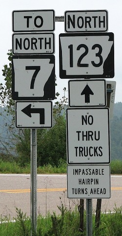
HERE IS THE SIGN ALL BIKE RIDING ENTHUSISTS THRILL TO SEE!!!!
This route starts at the intersection of Hwy 7 and Hwy 123 which is about 40 miles north of Russellville, AR in a town called Lurton, AR. From here take Hwy 123 northeast up to Mt Judea.
There are no amenities on this ride --- just curves, lots of curves.
ARKANSAS: The Boxley Valley Run
Just start in the town of Elkins, AR and head east on Hwy 74 all the way Jasper. This takes you thru some of Arkansas best scenery. Boxley Valley is one of the few place where Elk herd can be seen in Arkansas. A real treat for the eyes and a 5 becauese of the wildlife and scenery you'll see along the way! There are lots of gentle curves and some hills. The roads are old but they are still in good shape. There isn't much traffic most of the time.
Not alot in the amenities on this ride. Jasper has some good places to eat. You can get an Elk burger here! Along this route you'll also pass by or through 2 wilderness areas (Upper Buffalo Wilderness Area and Ponca Wilderness Area) and 1 state park - Lost Valley Ponca State Park.
Not alot in the amenities on this ride. Jasper has some good places to eat. You can get an Elk burger here! Along this route you'll also pass by or through 2 wilderness areas (Upper Buffalo Wilderness Area and Ponca Wilderness Area) and 1 state park - Lost Valley Ponca State Park.
ARKANSAS: Highway 103 Run
Begin your run in the town of Green Forest and head west out of town on U.S. 62. About 1 mile later, you'll find Route 103 and you'll want to take a left on to it (heading due south). Now you just follow it about 11 miles until it ends at U.S. Highway 412, 3 miles south of Rudd, AR.
ARKANSAS: Northwest Arkansas Tour on Highway 62
Hwy 62 runs from Rogers, Arkansas over to Eureka Springs. The last seventeen miles between Gateway and Eureka Springs is the best. If you are coming from Missouri take Hwy 37 South out of Monett, Missouri down thru Seligman into Gateway then East on Hwy 62.
ARKANSAS: Scenic Route from Hot Springs to Eureka Springs
This route starts in Hot Springs AR.
- From Hot Springs take Hwy 7 North 73 miles through Russellville, AR
- Now take AR 164/AR 7 North for 14 miles to Hargarville, AR
- Now take AR 123 North 28 miles to Sand Gap, AR
- Now take Ark Hwy 7 North 4 miles to Ark 123
- Now take Ark 123 north 16 miles to Ark 374
- Now take Ark 374 west 8 miles
- Now take Ark Hwy 7 North 5 miles to Jasper, AR cross Buffalo River
- Now take Ark 74 West 14 miles
- Now take Ark 43 North 4 miles through Ponca, AR
- Now take Ark 103 North 12 miles to Osage, AR
- Now take US Hwy 412 West 3 miles
- Now take Ark 103 North 14 miles
- Now take US Hwy 62 West 19 miles through Berryville, AR to Eureka Springs, AR.
Many curves, switchbacks, not many straight spots on these roads. Crossing many creeks, rivers, look out for the one lane bridges. Elevation as high as 2200 ft. Many 10 & 15 mph switchback. The road conditions are all good, if there has been a lot of rain some rock and mud may be in the curves.
There are several small towns along this route. Many places to camp Russellville AR, food and Gas. Haw Creek Falls, 14 miles north of Hagerville on Ark. 123. Small mountain stream with picturesque falls, rocks and bluffs; fishing; access to the Ozark Highlands Trail; campgrounds. Nice stopping point in Jasper AR, Eats, Gas, Motels, store with gas, small deli and picnic tables overlooking the Buffalo River. Berryville is nice size town with everything needed. Eureka Springs, so many things to do hard to list them all, one of the top arts and culture destinations, Passion play, Beaver lake and lots of hotels and shopping.
ARKANSAS: Boston Mountains Scenic Drive
The route starts north of Alma in Rudy, AR on Hwy 71. Just take and stay on Hwy 71 heading north all the way up to just south of Fayetteville.
This route used to be the only link to north west Arkansas. It offers impressive mountain vistas. Along the way are small mountain towns, roadside farms, antique and other shops. At Winslow your can take a detour over to Devil's Den by heading west of Rt 74. The route was once an old stage coach line and has some impress small towns like Mountainburg, Winslow, and West Fork. Mount Gaylor I believe to be the highest point with an old watch town sitting along side the highway. This used to be one of the highlights of Hwy 71 till I-540 took most of the traffic.
The route rises and falls with the mountain landscape and includes a healthy collection of twists and turns any biker would enjoy. If you choose to detour over to Devil's Den you will experience some of the best twist backs around.
There are small towns along the way that offer old style Diary Bar service like Mountainburg. If you take the detour to Devil's Den State Park you will really enjoy the scenery and the amenities of the park.
ARKANSAS: OZARK HIGHLANDS SCENIC ROUTE
Begins in Clarksville, AR off I-40. Take Hwy 21 north up thru the Ozark National Forest. Heading North up thru Fallsville on to Boxley, AR.
The Ozark Highlands Scenic Byway passes through a rugged section of the Boston Mountains (located in the Ozark National Forest) in the Ozarks. This is one of my favorite roads because you ride and never pass another car. There are many turns and hills that made this ride one of the best in Arkansas.
The area is packed with outdoor opportunities like hiking, canoeing, caving, rock climbing, fishing, hunting, mountain biking and horseback riding. A herd of about 450 elk roam the Buffalo River corridor at Boxley Valley, Steel Creek, Kyle's Landing, Erbie, Ozark, Pruitt, and even on private lands, and Newton County is known as the Elk Capital of Arkansas.
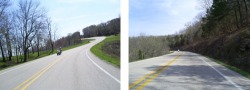
ARKANSAS: Arkansas At Its Best - Highway 7
The directions to this route are very straight forward. Start the route in Harrison Arkansas and simply head south on Route 7 all the way to Hot Springs Arkansas.
On this route you will travel through two national forests and one national park. The route takes you from Harrison to Hot Springs Arkansas and you should plan on taking a few detours if you would like to see more of the countryside. You’ll be traveling through the rugged Ozark Mountains and see canyons, lakes, rivers, forests and ample wildlife. For those of you who never thought of Arkansas as a state with outstanding scenery, this route may change your mind!
This is among the best of motorcycle roads in all of Arkansas. Plenty of twists and turns, hills and valleys to keep you leaning and grinning.
The route running from north to south starts out in the quaint town of Harrison where you will find ample lodging, a collection of small craft shops and museums. Heading south, many of you will enjoy a tour of Mystic Caverns. Two large caves offer visitors a view of subterranean rock formations including two favorites that resemble a giant pipe organ and a crystal dome. If you take a detour off of highway 7 onto Rt. 74 you can travel to the town of Ponca. From here you can reach Buffalo River and enjoy floating and canoeing along one the nations National Rivers (equipment rentals are available). North of the town you will find a trail that leads to Hemmed-in-Hallow, and see a collection of waterfalls that stand 175 feet and travel down huge limestone cliffs – you won’t be disappointed by this journey. Traveling further south you will see Arkansas' version of a Grand Canyon. The Buffalo River carved this gorge, leaving behind tall red rock bluffs. In the distance you will see the Boston Mountains. If you care to stay in this area you may want to try the Cliff House Inn (870-446-2292), which gets its name from its position hanging over the canyon itself. Travel shortly down the road and you can take a detour along Rte. 16 to see a massive 130 ft. natural bridge carved out of sandstone by a small stream. The place is known as Alum Cove Natural Bridge Recreation Area. Take a 4-mile detour east on Rte. 16 to see a large collection of rock formations known as Pedestal Rocks because of their unique structure (large boulders upheld by much smaller columns of rock). Traveling further along route 7 will lead you by many antique and craft shops and finally you will enter the million plus acres of the Ozark National Forest ((501)968-2354). This National Forest offers visitors caves, waterfalls, streams and abundant trails through its forests and prairies. An entire vacation could be spent in this one park. Further south along 7 you will pass through Dover (more antiques) and then through the large town of Russellville and make your way down to Dardanelle where you can visit the Lake Dardanelle State Park ((501)967-5516). At Rte. 155 you need to head west towards Mount Nebo State Park. On the way you will travel some great zigzag roads that will convince you that a motorcycle is the only way to travel. Another detour you will love is further south where you will want to take Rte. 154 for a great tour of the Arkansas river valley that you can take till Holla Bend National Wildlife Refuge or further up the road to Petit Jean State Park home of a the 94 ft. tall Cedar Falls waterfall. Heading down route 7 further south will make its way through the Ouachita National Forest that offers ample camping and hiking opportunities. Finally the route takes you down into the city of Hot Springs Arkansas with a number of coffee houses, craft shops, art and antique boutiques, and many lodging possibilities. You also will want to experience first hand what the town is know and named for – hot springs. These mineral-laden hot springs can be found at the Hot Springs National Park. There is an operating “bath house” known as the Buckstaff and the Fordyce that serves as a museum and visitor center. There are many roads in this area that offer a great collection of zigs and zags yet every motorcyclists must travel the road leading up to the observation tower at the summit of Hot Springs Mountain.
ARKANSAS: THE ARKANSAS PIG TRAIL (Arkansas Highway 23)
From Interstate 40, near the town of Ozark (between Little Rock and Fort Smith), you will want to take exit 35 north on to Hwy 23 and into (and through) the town of White Oak, AR (Franklin County). Start this motorcycle road where Hwy 23 and Route 352 intersect. From here continue heading north on Hwy 23 and the fun starts when you cross into the Ozark National Forest … here is where the Pig Trail starts and continues all the way up to where Hwy 23 and Hwy 16 meet (at Brashears Cemetery and just south of the town of St. Paul, AR).
The rugged and forested Boston Mountains region of the Ozark Mountains provides the setting for this route, which often runs through a tunnel of foliage during spring, summer and fall. Spring wildflowers and brilliant autumn foliage make the route especially popular during those seasons. The route crosses the Mulberry River and the 165-mile Ozark Highlands Trail. Additional scenery information submitted by "Bone" (Sep 06) - "Deep wooded terrain, many 15mph hairpins with short straights between them with dropoffs on one side cliffs on the other. The road runs between valleys beside streams to mountain hard curves. This has been called the Arkansas Dragon, and at the one general store midway of the run, you can buy pins and patches of this. The ride can be extended northward another 18 miles to the town of Huntsville where there are complete services, food, gas, lodging. "
Ark. 23 from the south boundary of the Ozark National Forest to its intersection with Ark. 16 at Brashears. Hair raising hairpin turns, switchbacks, curves, curves, hills, curves and more curves! Not for the faint of heart.
The Pig Trail provides numerous recreational opportunities. Enjoy open fields and pastures, rugged cedar breaks and rocky bluffs or the banks of the Mulberry River. If fishing isn't your favorite activity, brave the rushing waters for a few hours of whitewater rafting or kayaking and afterward spend a night under leafy boughs while the rushing waters from the White River sooth you to sleep. Start off the next day with a hike along the Ozark Highlands Trail, and capture the widespread views beneath you with your camera. There is Turner Bend Store and campground at the "end of the trail" where you can get a patch that says "I survived the Pig Trail" and a campground, along with several lodges and cabin sites along the beginning and end of the ride.
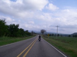
TENNESSEE: "The Snake" - Hwy 421/34
From Mountain City, TN, take Hwy 421 North through the Cherokee Nat'l Forest, Shady Valley, TN, and on to Holston Valley, TN. As a short side trip, take TN 133 North 10 miles to see Backbone Rock.
This route takes you from Mountain City, TN to Holston Valley riding through the Cherokee Nat'l Forest. Riding through mountains and valleys with great vistas and ending with a view of South Holston Lake. As you leave Mountain City, riding through the Cherokee Nat'l Forest, there are some great views as you ascend over the first mountain ridge on some of the best twisties in the area. The climb over the second ridge is as good as the first with more twisting/turning roads that will leave you exhilarated. The ride ends up in Holston Valley after crossing Holston Lake. We hold our Annual Rune Rally in nearby Erwin, Tn and this ribbon of asphalt one of our favorites.
Mountain City and Holston Valley have everything you want and need for a great get away, and in the middle of this ride is the Shady Valley Country Store. They have great burgers/sandwiches, snacks and souvenirs too.
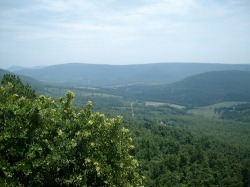
TENNESSEE: HIGHWAY 66
Start in Rogersville, TN and head North on Highway 66. Stay on this until you get to Hwy 31 and go South to Hwy 33 West to Hwy 25E South. Now you will enjoy the view at the clinch mountain lookout. This will bring you into Morristown, TN after you head South off Clinch Mountain. All together this is probably a 50 mile ride or better if you do this. It's only around 20 miles on Hwy 66 from Rogersville, TN to Sneedville, TN. Hwy 66 can be found at Bulls Gap, TN. if you want to start here it gives you a few more miles on 66.
Most of the scenery is wooded areas with small farms and old buildings located on the ride. Just good old back country riding. Some rivers and smaller streams and mountain views. For the most part pavement is in good shape just need to take it slow because there are some tight turns. You can also take Highway 31 south out of Sneedville, TN. It is great riding that way with nice mountain views also and some good curves. Overall, many curves and tight turns good riding though just take your time and enjoy.
Some old towns like Rogersville and Sneedville with some camping and lodging. Lots of good country cookin. The lookout on Highway 25 South on Clinch Mountain offers some great lake and valley views. There are little roadside eateries on this route and in Morristown, TN. There are many other places to eat. Rogersville has nice places to eat just not as many. There is camping on Hwy 25 on the Cherokee Lake and a mall in Morristown, TN also.
TENNESSEE: North Central Tennessee Tour on US-127
Started at Crossville, TN on US-127 North. Stop Forbus, TN to visit the "Old" store. Great local items. Good sandwiches! Travel North about a mile and take SR-325 to Byrdstown, TN. This is a Scenic curvy back road to travel at about 30 mph. Nothing to see but country farms. At Byrdstown take SR-111 south past Dale Hollow Lake to Livingston, TN. 1 mile South of Livingston take SR-84 to Monterey, TN and I-40. This is a comfortable 4 hour ride including good stops. It took Papa Jay 6 hours because he likes to talk to the local people way too long. Start and end on I-40 for easy access.
Lots of farm land that look like "Post Cards". Undeveloped land and hills provide great views. Rolling hills. Old abandoned school houses are interesting stops, but be aware farmers use some for storage! Two lane roads in great condition. Lots of shaded curves which will be covered with leaves in the late fall, so ride slow. Speed limits from 35 to 55 but take your time.
Lots of road side stores but spaced out. The Old Country store at Forbus is a must stop. Fresh made sandwiches are great. Don't get in too much of a hurry, this is a "different time zone", a little slower. Local honey, jams and such for sale so keep a saddle bag ready! Pall Mall is a great place to stop to explore the life of Sgt Alvin York, WWI Medal of Honor (MOR) recipient and Highest decorated WWI soldier. Visit his Grave site. Directions are posted by signs. Byrdstown offer a few roadside restaurants but I'm usually going to Dale Hollow's boat dock restaurant. Have a map of the area with you incase you want to explore some of the roads around Dale Hollow Lake. Great viewing!
TENNESSEE: BACK ROAD #4
Use I-40 East, I-81 North to Exit 30. Take 70 North to Kyles Ford, 33 South to Sneedville, 63 North toward Shawanee/Harrogate area.
Watch closely for Indian Creek Road on your right (just prior to Shawanee/Harrogate). Turn left on 58 to Cumberland Gap, TN. Stop to tour the town. Go back to 58 to 25E and into KY. (Recommend you stop at the Cumberland Gap Visitor center).
Now time to head home by taking 25E South, watch for bypass around Tazwell. Go past 33 (north), cross a bridge (small sign for Clinch Mtn Winery). Turn right after the bridge (street name???).
Go about 5 miles to Blankenship Road and turn left(very sharp turn) to a stop sign at 131. Turn right on 131 thru Washburn. Turn left (y's to left before 131 crosses a RR Track)on Joppa Mountain Rd. Continue to a stop sign. Turn right on 11W thru Blaine. Turn left on Mine Rd to 11E. Turn left on 11E to 139. Turn Right on 139, cross 25W to Snyder Road and on to Exit 407.
There are plenty of places to obtain gas or food at the beginning and end of the route and a couple places in between. But they are scattered - so start with full gas tank and stomach. I recommend taking a bathroom break at Sneedville as there are no other stops until you get to Cumberland Gap area.
Special Notes:
I-40 and I-81 save time for the best part of the ride. The fun starts at Hwy 70 and continues on 33, 63. Hwy 70, 33, and 63 are all nice MC Roads. Hwy 63 is steep, twisty, switchback, for 3 milse the rest of the route goes thru a beautiful valley and then a nice cruising curvy road from intersection 345/63. Also, an old country store (Martin Grocery)on 63 at a "T" Intersection just after Sneedville (drinks, cold sandwiches, friendly lady runs it - no bathroom). See Picture.
Cumberland Gap, TN is well worth a stop to tour the town, even hike the Gap Trail if you desire or a short part to an old smelter. Then thru the tunnel into KY and the Cumberland Gap Visitor center (movies and a beautiful switchback road to the Overlook where you see TN, VA, KY). See pictures.
A couple of highlights on the return home are a mountain road, Blankenship Rd (see picture)and Joppa Mountain Road with curves and switchbacks.
Alternate Route Return - stay on 25E to I-81 to I-40 or check TN Map.
TENNESSEE: Crossville to Standing Stone to Celina
Start in the town of Crossville, TN and head out of town North on Hwy 298/Genesis Rd. Stay on Hwy 298 till it runs into Hwy 62. Take a left and get on Hwy 62 heading west and go 20 miles to Hwy 127. Turn right on Hwy 127 (heading North) 5 miles to Hwy 85/52. Take a left on Hwy 85/52 (heading West) thru Alpine, TN and on to Livingston, TN. Note: after Livingston Hwy 85/52 splits … stay on Hwy 85 heading west for about another 20 miles till Hwy 85 runs into Hwy 53 (Gainesboro area). Turn right on to Hwy 53 (heading North) and go 11 miles till you see Hwy 52/Livingston Rd on the right (as you're pulling into Celina, TN). Take a right on to Hwy 52/Livingston Rd (heading East) and go 10 miles to Hwy 136/Standing Stone State park Rd. Take a right on to Hwy 136/Standing Stone State Park Road (heading South) and it will take you into Standing Stone State Park. When you get to the park sign entrance take a left and proceed into the park and enjoy. When you're ready to leave, get back out to Hwy 52 and take a right (heading east-southeast) through Livingston … stay on Hwy 52 as it turns an easterly direction and takes you into Jamestown, TN.(approx 38 miles). Turn right on to Hwy 127 (heading South) and take this to the end point of Crossville, TN (approx 35 miles).
Wonderful two lane roads, rolling hills and great fall colors when in season. Light traffic, no major cities. Standing Stone State Park is good place to relax with a walking bridge over creek and decent amenities.
Good road conditions some tight switchback roads to Livingston, and toward Jamestown. No interstates but good good road quality!
Lots of nice little towns to stop at along the way … spaced out nicely. Possible places to stop include Crossville, Livingston, Jamestown, Standing Stone State park.
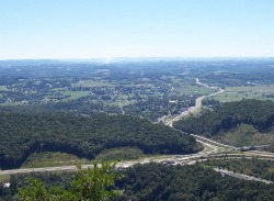
TENNESSEE: Real Tennessee Back Roads #3 (Norris dam, Savage Gardens, Big Ridge State Park)
Note: These directions are very specific and listed below in detail.
Start and End at Exit 407 of I-40 in Sevierville, TN.
Go north on Snyder Road (Past the Smokies Ballpark).
Cross 25W/70 onto Hwy 139. Turn left onto Hwy 11E - 4 lane (stop sign).
Turn right onto Mascot Road (stoplight and gas station)
Curve to right onto Mine Rd (Mascot Rd becomes Mine Rd at a sweeping right hand curve).
Turn left onto Hwy 11W - 4 lane (stop sign)
Turn right onto Roberts Rd (watch closely for this turn).
Turn right on Washington Pike (stop sign and station)
Imediately turn left onto Roberts Rd.
Turn left onto Emory Rd, 331 (stop sign, T Interesection).
Continue straight on Emory Rd (it becomes 131 at 131/331 intersection, stop sign)
Continue straight on Emory Rd (still 131) at the intersection with 33 (stop light).
Turn right on Norris Freeway, Hwy 441, - 4 lane road (stop light) Follow Hwy 441, ccross 61 thru the town of Norris, TN (you may want to explore some side streets in the residential section of Norris to see some little houses built in the 40s and 50s).
Coming back to Norris Freeway, 441.
Continue on Hwy 441 to a stop sign after going thru town and turn right (Taht is still Hwy 441)
Continue on Hwy 441 (You will pass the tailwaters of Lake Norris on your left and a very nice Musuem of East TN and Norris Dam History on your right which includes a mill and old Barn - take the time to stop at both spots) Continue on Hwy 441 (You will pass a visitor center and cross the top of the dam for Lake Norris)
Watch for a left turn into the East Overlook (shortly after toping the curvy hill). Stop for a view of the lake and tail waters from about 200 feet above the dam .
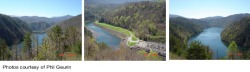
Beautiful country side and ride along the river with views of Lake Norris, Clinch River Tailwaters in Lake Norris Dam area. Plus, a nice museum with an Old Mill and Barn. Savage Gardens has some unique Rock Formations. Big Ridge Park has an Old Mill. This route has everything from nice cruising two lane and four lane roads to some very twisty areas on route 61 near Big Ridge State Park and a section near Norris Lake along the river that is somewhat narrow. Plenty of places for gas, snacks, food, etc in addition to the places to stop mentioned above. Check out the pictures below in the direction section.
Start and End at Exit 407 of I-40 in Sevierville, TN.
Go north on Snyder Road (Past the Smokies Ballpark).
Cross 25W/70 onto Hwy 139. Turn left onto Hwy 11E - 4 lane (stop sign).
Turn right onto Mascot Road (stoplight and gas station)
Curve to right onto Mine Rd (Mascot Rd becomes Mine Rd at a sweeping right hand curve).
Turn left onto Hwy 11W - 4 lane (stop sign)
Turn right onto Roberts Rd (watch closely for this turn).
Turn right on Washington Pike (stop sign and station)
Imediately turn left onto Roberts Rd.
Turn left onto Emory Rd, 331 (stop sign, T Interesection).
Continue straight on Emory Rd (it becomes 131 at 131/331 intersection, stop sign)
Continue straight on Emory Rd (still 131) at the intersection with 33 (stop light).
Turn right on Norris Freeway, Hwy 441, - 4 lane road (stop light) Follow Hwy 441, ccross 61 thru the town of Norris, TN (you may want to explore some side streets in the residential section of Norris to see some little houses built in the 40s and 50s).
Coming back to Norris Freeway, 441.
Continue on Hwy 441 to a stop sign after going thru town and turn right (Taht is still Hwy 441)
Continue on Hwy 441 (You will pass the tailwaters of Lake Norris on your left and a very nice Musuem of East TN and Norris Dam History on your right which includes a mill and old Barn - take the time to stop at both spots) Continue on Hwy 441 (You will pass a visitor center and cross the top of the dam for Lake Norris)
Watch for a left turn into the East Overlook (shortly after toping the curvy hill). Stop for a view of the lake and tail waters from about 200 feet above the dam .
Beautiful country side and ride along the river with views of Lake Norris, Clinch River Tailwaters in Lake Norris Dam area. Plus, a nice museum with an Old Mill and Barn. Savage Gardens has some unique Rock Formations. Big Ridge Park has an Old Mill. This route has everything from nice cruising two lane and four lane roads to some very twisty areas on route 61 near Big Ridge State Park and a section near Norris Lake along the river that is somewhat narrow. Plenty of places for gas, snacks, food, etc in addition to the places to stop mentioned above. Check out the pictures below in the direction section.
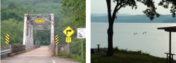
TENNESSEE: DEAL'S GAP
Deal's gap is not the easiest road to find on a map because it is just a small 11 mile stretch that hugs the border of The Great Smoky Mountains National Park on its very sparsely populated southwest corner. Most of the road lies in Tennessee yet a small section of it crosses into North Carolina. Suggest you use the Online Map Link to get your bearings. The closest town to the north end of Deal's Gap is Tallahassee, TN and the closest town to the south end of the road is Tapoco, NC. And, keep in mind that when you get close to the road, all the locals can point you in the right direction if you are not sure.
Beautiful Smoky Mountain scenery includes some lush forests and evergreen covered mountains. People from all walks of life are drawn to the seducing curves of the Dragon (other wise known as Tail of the Dragon) at Deal's Gap, also known as US Hwy 129. They make their pilgrimage to test their skills, or in some cases, to be bitten by the Dragon. The area surrounding the Dragon was one of the last areas of North Carolina to be settled due to its inhospitable terrain. The southern Appalachian Mountains are made up of two separate ranges; the eastern range is the Blue Ridge Mountains, and the western range is known as the Great Smoky Mountains. For thirty-six miles along the TN/NC border the GSM are more than 5k feet in altitude with 16 peaks stretching to more than 6k feet. All of this altitude translates to treacherous travel, especially for the pioneers in their day, but also for us as motor-sport enthusiasts today.
318 curves in 11 miles - what more needs to be said? Well these just aren't any curves as there are many sharp turns, steep drop-offs, not many cars, lots of bikes ... overall a real challenging road. The road is mostly in good shape as its become a real tourist draw and the local government knows to keep the road in good shape and the people will keep coming. Its challenging and exciting for some, scary to beginning riders, be careful on this one.
By the time you reach the plateau from which the end (otherwise known as the turn around) your will be spent but very eager to hit the tight turns that are banked to perfection. Pay very close attention to on coming cars and large trucks as the turns are hairpin and they do come into your lane!
Not many pull-outs, one store at the end of ride, be sure to go in and see pictures of crashes that have happened along the road.
- GAS STATIONS : Deal's Gap Motorcycle Resort
- FOOD: Dragon's Den Grill, , located at the resort
- HOTEL: Deals Gap Motorcycle Resort
- REPAIRS: NONE, You can get some very minor repairs at the resort. Nearest
repair is Wheelers, 16 miles south or the 129 Pit Stop located in TN 12 miles
north of the Gap.
- PULL OFF'S/OVERLOOKS: 1, Dragon overlook.
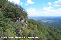
TENNESSEE, KENTUCKY, VIRGINIA: Tri-State Mountain Tour - Tennessee, Kentucky, and Virginia
- Beginning in Kingsport, Tennessee take 11W south until you reach Bean Station, Tennessee.
- At Bean Station follow signs to 25E North to Tazewell, Tennessee.
- At Tazewell, Tennessee stay on 25E North (right at the red light) towards Middlesboro, Kentucky. Ride through 25E tunnel into Kentucky.
- At the first exit past tunnel get off and follow the signs to the Pinnacle Overlook. Follow the signs up the mountain wto the overlook.
- After you've taken in the awesome view, head back down and get back on 25E South. This will take you back through the tunnel and into Kentucky.
- After passing through the tunnel take your first exit which is US 58 East heading to Jonesville, VA.
- Follow signs on US 58 to Duffield, VA.
- At Duffield take a right at red light taking US 23 to Gate City. From Gate City your just a few miles north of where you started in Kingsport, TN (just take 23 south to get down there).
Be sure to take a camera. Plenty of rolling hills and farmland. Ride along Cherokee Lake and Norris Lake. Up and down one mountain in TN., 1 mountain in Kentucky, and 2 mountains in VA. Really enjoyed riding through the tunnel into Kentucky where there is a State park (Cumberland Gap National Historical Park) that offers a spectacular view from the "Pinnacle Overlook" where one can see the three states that you cover on this route.
Most of the roads are 4 lane. There was not much traffic on most of the roads even though it was mothers day weekend. There was some road work on the Tazewell side of Clinch Mt. on 25E. Also a little work in Damascus, Va. Mostly rolling hills with some curve on the 4 mountains with the road going up to the Pinnacle in Kentucky being very curvy.
Plenty of places to stop and get a drink. After leaving Kingsport one does not see any restraunts until Rogersville, TN. Then none until Tazewell, TN. After Tazewell you'll travel into Kentucky and want to check out the Cumberland Gap National Historical Park (& Pinnacle Overlook located in the park). There are some eating places scattered throughout VA. until you get to Duffield. Afterwards one has to wait till you get to Gate City, VA or back to Kingsport, TN. to eat.